Hundreds of previously unidentified Roman forts have been discovered through satellite imagery from the Cold War era.
Experts have stated that recently released images from a cold-war spy satellite have shed new light on the operations of the Roman empire. These images have uncovered numerous forts that were previously unknown, greatly impacting our comprehension of this ancient civilization.
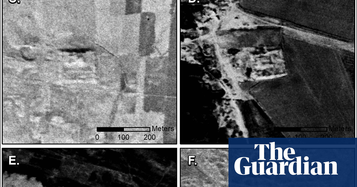
Archaeologists studying aerial images captured in the 1960s and 1970s have identified 396 previously unknown Roman fort sites in Syria and Iraq located throughout the Syrian steppe.
New research, released in the academic journal Antiquity, has prompted a reassessment of life at the Roman border.
In 1934, Antoine Poidebard, a French Jesuit explorer who specialized in aerial archeology in the Middle East, conducted a survey of the region and documented 116 forts.
Previously, it was believed by historians that these forts were constructed as a defensive barrier to safeguard the eastern region of the empire from attacks by Arabs and Persians, as well as from nomadic tribes who frequently raided and captured slaves.
According to the authors, recent findings suggest that the frontier was not a constant site of violent conflict, but rather a dynamic and active hub for cross-border trade. They assert that the forts played a role in facilitating a system of caravan-based trade, communication, and military transportation between different regions.
The question posed by the authors is whether it was a wall or a road.
Prof Jesse Casana, lead author of the research from Dartmouth College in New Hampshire, USA, stated that since the 1930s, there has been a discussion among historians and archeologists about the strategic or political intentions behind the fortifications. However, most scholars have accepted Poidebard’s initial observation that there was a series of forts marking the eastern border of the Roman Empire.
The 396 new sites, hidden by modern-day development, are widely distributed across the region from east to west, which does not support the argument that the forts constituted a north-south border wall.
It is now believed by researchers that the forts were built to aid in cross-border trade, safeguarding caravans that traveled between the eastern provinces and non-Roman territories. They also served as a means of communication between the east and west.
The authors stated that this suggests the boundaries of the Roman world were not as strictly defined and exclusive as previously thought.
The Romans were a society focused on military power, but they also placed importance on trade and communication with areas beyond their immediate rule, according to sources.
The pictures analyzed were a component of the initial spy satellite initiative during a period of political tension between the United States and the Soviet Union and their respective allies, the Western and Eastern blocs.
Casana stated that the images maintain a detailed, two-dimensional view of a landscape that has been greatly influenced by current alterations in land usage.
He stated that it showcased the true significance of satellite imagery in capturing archaeological traits before they disappear.
Out of the 116 forts mentioned by Poidebard, we could only confidently confirm the existence of 38 based on archeological evidence. Unfortunately, a number of the potential Roman forts we discovered during this research have been demolished due to recent urban and agricultural growth, and many more are in danger of being destroyed.
As additional visuals are made available, including images from U2 spy planes, there is a greater potential for uncovering new archeological findings. Casana stated that thorough examination of these valuable data has tremendous potential for revealing future discoveries in the Middle East and beyond.
Source: theguardian.com