A second strong band of moisture known as an atmospheric river has reached California, prompting a warning of potentially dangerous flooding.
A new storm, fueled by an atmospheric river, is currently hitting California and posing a threat of severe weather in the region.
The National Weather Service issued a warning that there would be ongoing rainfall for 48 hours in areas that are already saturated across the state. These areas include the central coast, Los Angeles basin, and mountain ranges.
The agency stated in an update on Sunday morning that the heavy rainfall could result in dangerous flash, urban, and river flooding, as well as potential debris flows and mudslides.
Severe snowfall and powerful gusts of wind are anticipated to cause extremely difficult travel conditions in mountainous areas and destructive waves along the coastline.
The San Francisco area in northern California has received its first ever warning from the National Weather Service about the possibility of hurricane force winds. These strong winds have caused flight cancelations and diversions from the San Francisco airport. Additionally, the federal service has issued a rare “high risk” warning for flash flooding in Los Angeles, further south.
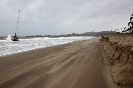
The Big Sur coast experienced wind gusts reaching 85mph on Sunday morning, causing power lines to fall and creating dangerous conditions on Highway 1. As a result, over 140,000 homes and businesses lost power along the California coast by Sunday morning, most likely due to the strong winds. It is predicted that the number of outages will continue to rise throughout the afternoon.
Prior to the event, towns situated on mountainous terrain, along raging rivers, or in proximity to areas recently affected by wildfires, were required to evacuate or received warnings to do so, including the cities of Ojai, Los Angeles, and Santa Barbara. As a precaution, water officials initiated the release of water from reservoirs that were close to their maximum capacity in both the Central Valley and Sacramento Valley regions, according to Karla Nemeth, the Director of California’s water resources department.
The flood arrives as towns throughout the state were still recovering from the previous week’s tempest, which brought heavy rain and thunderstorms on Wednesday and Thursday and pushed the limits of infrastructure.
Due to the already soaked grounds, the NWS cautioned that flash floods could happen at a faster rate. The NWS advised all individuals, particularly those in or near south-facing mountains, to make necessary preparations in case of potential evacuations during or prior to the storm’s arrival on Thursday.
According to climate expert Daniel Swain, there is a possibility of California experiencing more rain in the upcoming weeks. He mentioned in a YouTube video that during strong El Niño years, the rainy season usually reaches its peak in February and March. Swain also predicted that there could be 6-7 more weeks of potential storms and he wouldn’t be surprised if there was another significant storm cycle during that time frame.
El Niño, a climate pattern associated with increased ocean temperatures in the tropical Pacific, can supercharge atmospheric rivers like the ones now creating strong storms over California with vapor that evaporates off the warmer surface waters. While there can be variability, El Niño typically delivers hotter, wet winters in California and other parts of the US south-west.
after newsletter promotion
In California, precipitation can be a relief after enduring years of severe drought. However, the impact of a storm depends heavily on when it occurs and the temperature. Atmospheric rivers are responsible for most floods and damaging rainfall on the west coast of the US, but they also contribute a significant portion (60%) of the region’s water supply.
Unfortunately, California has received a significantly higher amount of rain rather than snow this year, making it harder to store and utilize water resources. The snowpack, which serves as a reserve for water, gradually releases into reservoirs, rivers, and soil during periods of low precipitation. However, the recent monthly survey showed that the snowpack is currently at only 52% of its average level. Water managers are optimistic that this trend will improve and result in a thick layer of snow in the Sierra Nevada range.
Currently, the California department of water resources reports that the state’s reservoirs were at 115% of the average level before this system. Additionally, flood stages have been observed in rivers in both northern and southern California. As the wet season in California continues, there are still several weeks left and the forecast indicates continued wet conditions. This has led to many areas in the state surpassing or approaching average levels of precipitation.
Experts have cautioned that this is a preview of what lies ahead as global temperatures rise, with wetter weather and reduced snowpack becoming the new normal. “This provides insight into the potential changes in California’s winters as the climate continues to warm,” stated Swain, highlighting the significance of both El Niño and the climate crisis.
Source: theguardian.com